Geophysical Domain Mapper Interface
The Geophysical Domain Mapper Interface allows users to map geophysical domains using statistical constraints. It enables a fast initial pass to draw the domains and then refine them in Geoscience ANALYST. Its capacity to take several data inputs allows for the combination of different geophysical data to map the domains. The interface is presented in Figure 11 below.
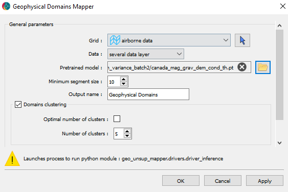
Figure 11 Geophysical Domain Mapper Interface
The mechanisms behind this interface are presented in the Inference Mechanisms section.
The different options available in the interface are:
Grid: The grid containing the data to be used for the inference.
Data: A data group containing the data to map. This group must be previously created in Geoscience ANALYST.
Pretrained model: A pretrained model to use for the inference. This model is a
*.ptfile provided by Mira Geoscience or obtained with the Training Procedure.Minimum segment size: The minimum size of the segment to create. All segments containing less grid cells than this value will be merged with the closest segment.
Output name: The name of the data to create. It will be a Referenced data associated with the input grid.
Domains clustering options:
If unchecked, the non-adjacent segments will be separated into different classes.
Optimal number of cluster: If this option is checked, the number of clusters will be automatically determined (time-consuming process).
Number of clusters: The number of clusters to create.
By pressing the OK button, the inference will be performed and the output will be created in the Geoscience ANALYST project as a referenced data.
The Figure 12 below shows an example of the Geophysical Domains detected by the application. The results have been obtained from 3 input layers: a magnetic layer, a gravity layer, and an elevation layer. This gives the geologist a quick first pass to draw the domains and then refine them in Geoscience ANALYST.

Figure 12 Example of Geophysical Domains detected by the application from 3 input layers